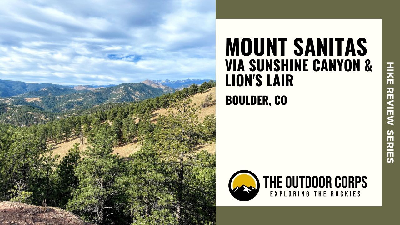
Mount Sanitas, a 6,821ft. peak in Boulder, Colorado, is an extraordinarily popular summit frequented by local hikers and trail runners. Although many pronounce the name as Mount “San-ee-tis,” the correct pronunciation is Mount “San-eh-toss,” which is derived from the word ‘sanitarium.’ In the 1800s, John Harvey Kellogg (of cereal fame), opened the Boulder Sanitarium and Hospital and its staff developed one of the main trails leading to the Mount Sanitas summit for sanitarium guests to use for recreation and health.
Today, Mount Sanitas is easily one of the best known recreational spots in all of the Denver/Boulder metro area. With multiple trails leading to the summit, some right from the edge of downtown Boulder, Mount Sanitas offers a fantastic opportunity for an escape into nearby nature. At the summit, visitors overlook downtown Boulder and the plains to the east. But, the real treat are the views from some of the connector trails looking west towards foothills and Indian Peaks Wilderness summits. For these views, and a more moderate summit ascent, we prefer the 5.0 mile loop route beginning at the Centennial Trailhead via the Sunshine Canyon Trail, linking with the Lion’s Lair Trail, and concluding with a descent down the Mount Sanitas Trail. We hope you’ll enjoy Mount Sanitas as much as we do!
HIKE REVIEW SERIES: Mount Sanitas Loop
Mount Sanitas Loop Guide
Route Information
- Round Trip Distance: 5.0 miles
- Elevation Gain: 1,265ft.
- Trail Type: Loop
- Trailhead: Centennial
- Coordinates: 40.020229, -105.297741
- Dog’s Permitted: Yes; not Lion’s Lair


Route Instructions


- Step 1 - Trail access begins at the Centennial Trailhead parking area. We prefer to start this hike in a clockwise direction, beginning with the Sunshine Canyon Trail. Hike the small set of stairs to head towards Sunshine Canyon Trail.
- Step 2 - You’ll quickly reach an intersection with the Red Rocks Trail to the left and the Sunshine Canyon Trail to the right. Bear right at the trail post and start along the Sunshine Canyon Trail.
- Step 3 - The Sunshine Canyon Trail parallels Sunshine Canyon Drive for about one mile and has limited elevation gain. You’ll shortly connect with the Lion’s Lair Trail and be in much denser forest with a steeper ascent.
- Step 4 - Cross Sunshine Canyon Drive to reach the Lion’s Lair Trailhead, up the small set of stairs. Please note, dogs are not permitted on the Lion’s Lair Trail.
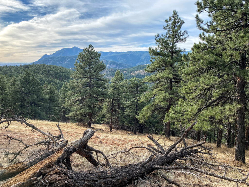
- Step 5 - Once on the Lion’s Lair Trail, the trail begins a much steeper ascent via a number of switchbacks. As you ascend, better views of the nearby foothills will start to appear.
- Step 6 - As you continue ascending the Lion’s Lair Trail, you’ll eventually reach a junction with the Lion’s Lair Spur Trail on the left. This spur trail connects to another parking lot off of Sunshine Canyon Drive. Stay to the right on the Lion’s Lair Trail and keep ascending.
- Step 7 - Views of the surrounding foothills to the west continue to improve along the ascent of the Lion’s Lair Trail.
- Step 8 - At approximately 6,500ft., the forest opens up with even more expansive views of nearby foothills.
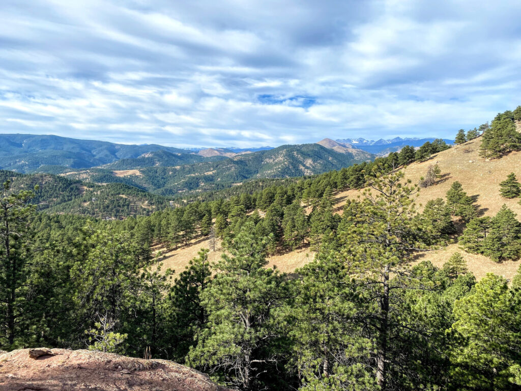
- Step 9 - A short distance further up the Lion’s Lair Trail, glimpses of Indian Peaks Wilderness mountains will come into view to the west.
- Step 10 - At approximately 6,700ft., the views to the west get even better and the mountains in the Indian Peaks Wilderness become even more prominent. Look for North Arapaho Peak, the highest peak in the wilderness area, with an elevation of 13,502ft.
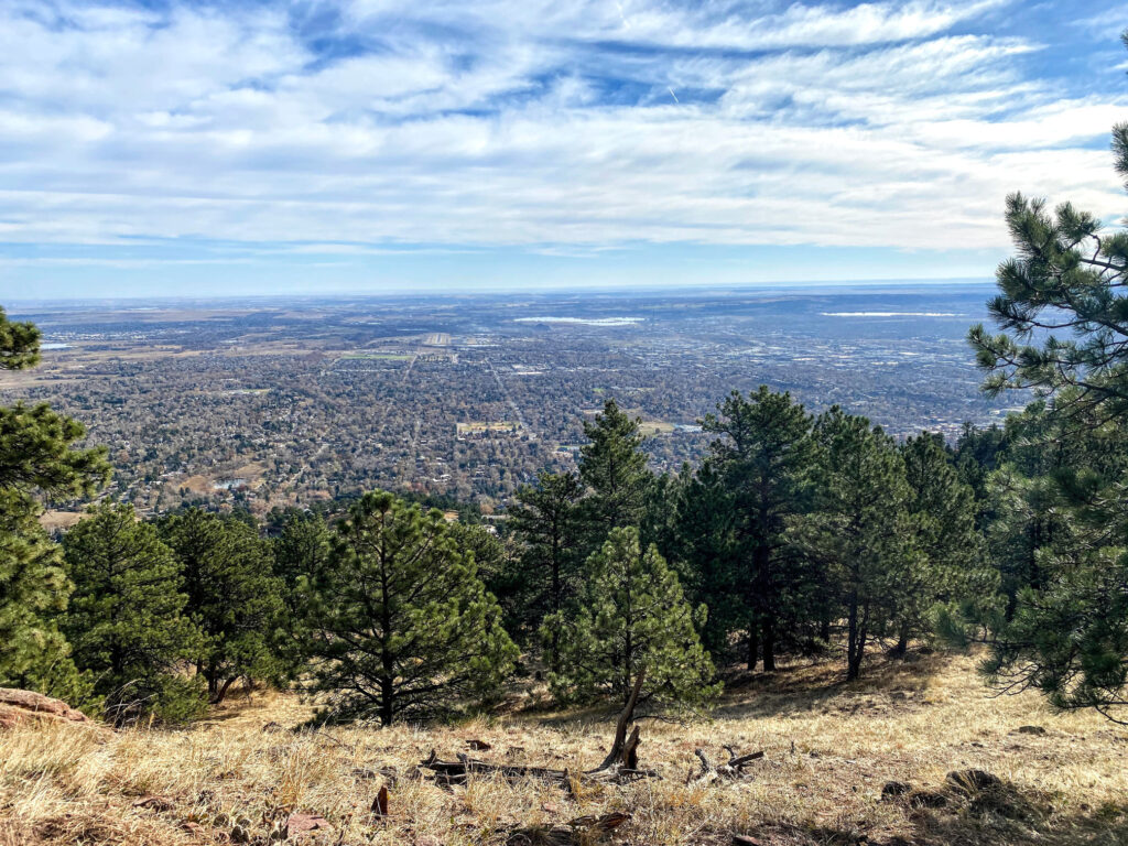
- Step 11 - A short distance further along the Lion’s Lair Trail, nearing the Mount Sanitas summit, the city of Boulder will come in to view to the east.
- Step 12 - Reach the junction with the Mount Sanitas Trail. Turn left for a short scramble up to the summit of Mount Sanitas, which is at an elevation of 6,821ft. Enjoy the expansive views of Boulder!
- Step 13 - Double back off of Mount Sanitas’ summit towards the way you came. Once off the summit, you’ll bear left to head down the steep and rocky Mount Sanitas Trail (rather than right, which takes you back to the Lion’s Lair Trail). Note the East Ridge Trail also descends from Mount Sanitas, which does not loop back to the Centennial Trailhead.
- Step 14 - Continue the descent down the Mount Sanitas Trail towards the Centennial Trailhead to complete the loop. You’ll eventually reach an intersection with a footbridge over Silver Lake Ditch in addition to other spur trails. Stay on the Mount Sanitas Trail and reach Sunshine Canyon Drive to end at the Centennial Trailhead parking area across the street.
PLANNING TIPS
Regulations
- Parking Lot Hours: Closed between 11:00pm – 5:00am.
- Pets: Permitted on Mount Sanitas; but not permitted on Lion’s Lair Trail.
- Bikes: Not permitted.
- Camping: Not permitted.
- Leave No Trace: Please stay on designated trails and pack out any trash/dog waste.
Getting There
This loop hike begins at the Centennial Trailhead, just off of Sunshine Canyon Drive. From downtown Boulder, head north on Broadway passing the Pearl Street Mall. Turn left onto Mapleton Ave., heading up a small hill towards a residential area of Boulder. Mapleton Ave. eventually turns into Sunshine Canyon Drive. The Centennial Trailhead parking area is on the lefthand side of the road.
Parking
Park at the Centennial Trailhead parking area, which is just off of Sunshine Canyon Drive. There are no fees to park here, unlike some of the other Boulder OSMP trailhead parking areas. There are about 30 parking spots, which fill up extremely quickly, since trail running and hiking up Mount Sanitas is an incredibly popular activity. A restroom is located at this parking area.
Weather Forecast
The Mount Sanitas summit is at an elevation of 6,821ft., so you’ll gain about 1,300ft. of elevation on this hike. For safety purposes, please be sure to check the weather forecast before hiking up to the summit.
RECOMMENDED HIKING APPAREL AND GEAR
Ten Essentials
Even on a day hike, you should carry the appropriate type and amount of gear, clothing, food, water, and other essentials. For certain, make sure that your packing list includes the Ten Essentials.
Hiking Boots
The Merrell Moab hiking boot lineup offers a good balance between weight and foot protection. These are great for scrambles and are constructed with waterproof membranes so you don’t have to worry about damp feet if the weather turns or you have to splash through streams or puddles along the way.


Hiking Pants
We love prAna’s hiking pants for their quality and versatility. Indeed, their Zion (for men) and Halle (for women) are great on- and off-trail, especially for travel. Constructed with a durable UPF-50 fabric, a water-repellant finish, and utility pockets, these have become a staple in our wardrobe. If you intend to hike, consider hiking pants rather than shorts (both for warmth and sun protection).


Base Layer Shirt
Patagonia’s lineup of capilene base layer t-shirts are lightweight and moisture wicking. For our hiking t-shirts and base layers, we often turn to Patagonia products for their craftsmanship, durability, and comfort. Patagonia Capilene Cool Lightweight shirts are versatile and great for hiking and/or trail running.


Hiking Fleece
Depending upon the time of year (and time of day), a fleece hoody or jacket may come in handy. We like the Patagonia R1 as a midweight, but light, option for chilly morning starts. Available as a hoody or jacket, the Patagonia R1 is quick drying, breathable, and extremely comfortable.


Hiking Socks
For most of our hiking needs, we like Darn Tough socks over the multitude of options on the market. They last long and have an ironclad guarantee. In addition, Darn Tough has a variety of designs, ankle lengths, and cushioning options to choose from. We like the Hiker quarter length with light cushioning.


Headwear/Face Covering
We often wear a Buff as a neck gaiter to protect from the sun, given its UPF 50 protective construction. Buffs are also a great option to use as a face covering on the trail. In fact, there are 12+ ways of wearing a Buff, so it’s a versatile piece of gear.

Day Pack
If you’re out for a day hike or quick trail run, consider a super lightweight hydration vest. Nathan's Hydration Vests are minimalist packs with reasonable storage capacity and hydration reservoir compatibility.

Sunscreen
Sun Bum is our go-to sunscreen nowadays. We like its non-greasy feel and neutral fragrance. Any quality sunscreen will do, but Sun Bum SPF 30 is our choice for long days in the sun.

Trail Snacks
Taos Bakes, made in New Mexico, are some of the best tasting energy bars out there. Vegan and gluten-free, these bars pack in a nice dose of fiber and protein along with a touch of sweetness. Available in multiple varieties, such as Toasted Coconut/Vanilla Bean, Piñon Coffee/Dark Chocolate, and Pecan Praline/Maple Syrup.

Recommended books
We recommend picking up a few naturalist guides for general awareness of Colorado ecology. Mount Sanitas and the Boulder area are part of a diverse ecosystem and we think that it is incredibly helpful to be familiar with local plants, wildlife, and geology. An easy to use field guide will help identify species and further add to the enjoyment of the outdoors experience. We also included a few of our favorite Boulder area hiking/trail running guides, which covers Mount Sanitas and other nearby trails. Happy adventuring!
- Best Trail Runs Denver, Boulder & Colorado Springs
- Boulder Hiking Trails: The Best of the Plains, Foothills, and Mountains
- Plants of the Rocky Mountains
- Sibley Birds West: Field Guide to Birds of Western North America
- American Birding Association Field Guide to the Birds of Colorado
- Roadside Geology of Colorado
- Boulder, Golden (National Geographic Trails Illustrated Map)
Disclosure: Please note that this post contains affiliate links. We may receive a small commission if you buy a product or service through an affiliate link. This revenue helps us provide readers with helpful content to plan amazing adventures.