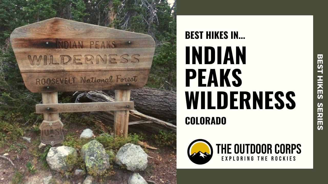
Indian Peaks Wilderness is located within the Arapaho and Roosevelt National Forests of Colorado. This stunning wilderness gets is namesake from the numerous mountains in the area named in honor of Native American tribes. In fact, the tallest mountain within Indian Peaks Wilderness is North Arapaho Peak, with an elevation of 13,502ft. While Indian Peaks Wilderness does not contain any 14er mountains within its boundaries, it does have plenty of 13er mountains and access to the Continental Divide Trail. To help you explore this beautiful area, we’ve curated a listing of what we think are some of the best hikes in Indian Peaks Wilderness.
Due to its considerable recreational opportunities, Indian Peaks Wilderness is an especially popular destination for local Denver and Boulder residents. In particular, the Brainard Lake Recreation Area can become fairly busy during the summer hiking season. However, this area is far less crowded than neighboring Rocky Mountain National Park since it is not as well known to out-of-towners. So, if you are looking for an alternative to the hustle and bustle of Rocky Mountain National Park, consider Indian Peaks Wilderness an excellent option. Below are some of our favorite hikes in the area that we hope you’ll enjoy as much as we do. Happy hiking!
BEST HIKES SERIES: Indian Peaks Wilderness
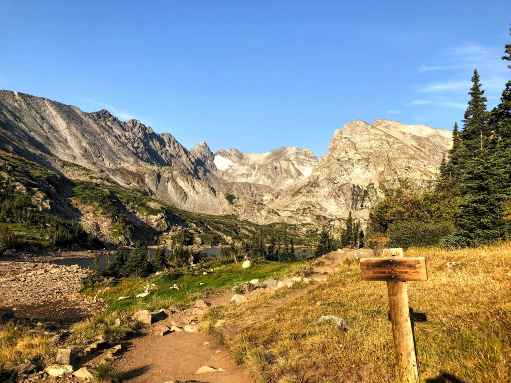
Pawnee Pass & Pawnee Peak
Pawnee Pass is easily one of the best hikes in the Indian Peaks Wilderness because of its breathtaking views. The journey up to Pawnee Pass takes you to an elevation of 12,550ft. However, if you are feeling extra motivated, consider continuing the hike to adjacent Pawnee Peak at 12,943ft. Although the trail to Pawnee Pass may be fairly busy, you’re likely to have little company on top of Pawnee Peak. Regardless of whether you only hike to Pawnee Pass or summit Pawnee Peak, you’ll be treated to amazing panoramic vistas of the Indian Peaks Wilderness. Furthermore, you can always say that you hiked along the Continental Divide, which is stellar in its own right.
The Pawnee Pass hike begins at the Long Lake Trailhead, which is accessed via the Brainard Lake Recreation Area. Be prepared to pay a fee when entering the wilderness at the Brainard Lake entrance. Although the Long Lake Trailhead has ample parking, it fills up extremely quickly during peak hiking season because of the area’s close proximity to Boulder and Denver. Therefore, we highly recommend that you get to the trailhead as early as possible to avoid traffic congestion into the wilderness area and not have to park in an overflow lot much further away.
- Round Trip Distance: 10.0 miles
- Elevation Gain: Strenuous
- Trail Type: Out and Back
- Trailhead: Long Lake Trailhead
- Coordinates: 40.078005, -105.584557
- Dogs Permitted?: Yes
Mount Audubon

Mount Audubon is an extremely popular hike in Indian Peaks Wilderness because it is an accessible 13er mountain with an elevation of 13,223ft. Indeed, with so many great hikes to choose from in the Indian Peaks Wilderness, the Mount Audubon hike may be our favorite because of its amazing vistas, including a nice view of Longs Peak. The hike to the summit is under eight miles round trip and is mildly challenging for a 13er. But make no mistake, you must be in proper shape to hike even the easiest of 13er mountains. Of course, if you’re looking to increase the challenge, consider tacking on neighboring Paiute Peak (13,088ft.) in addition to Mount Audubon. Most of the crowds on Mount Audubon will likely stay on that summit, so you can hike across the saddle to Paiute Peak for a less crowded summit experience.
The hike to Mount Audubon begins at the Mitchell Lake Trailhead, which is accessed via the Brainard Lake Recreation Area. Be prepared to pay a fee when entering the wilderness at the Brainard Lake entrance. Similar to other trailheads within Indian Peaks Wilderness, parking spots are ample, but they fill up quickly. So plan to arrive early, which is advisable anyhow if you are planning to hike in higher elevations. Also, always check the weather forecast before embarking on your hike.
- Round Trip Distance: 8.0 miles
- Elevation Gain: Strenuous
- Trail Type: Out and Back
- Trailhead: Mitchell Lake Trailhead
- Coordinates: 40.083354, -105.581774
- Dogs Permitted?: Yes
Mirror Lake and Crater Lake (Lone Eagle Peak)
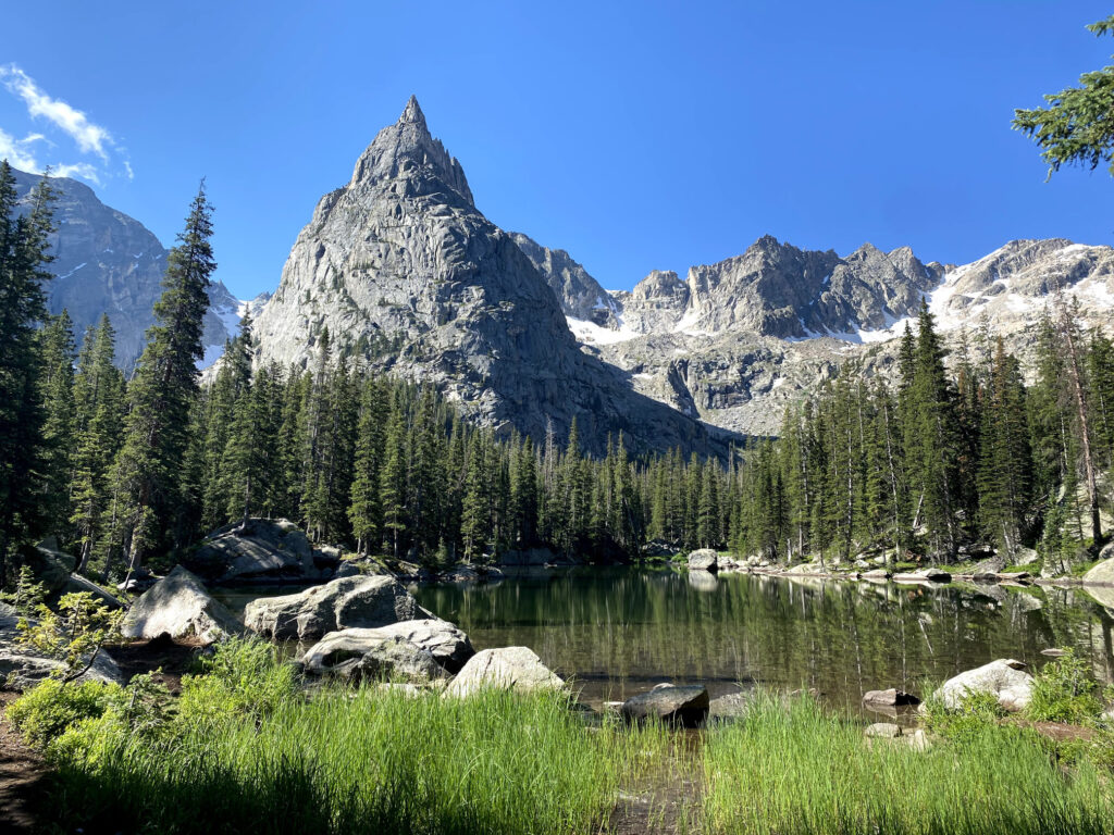
The Mirror Lake and Crater Lake hike is a lengthy adventure of nearly 15 miles roundtrip and is very popular particularly because of the incredible view of Lone Eagle Peak at Crater Lake. Lone Eagle Peak is perhaps the most distinctive feature in all of Indian Peaks Wilderness, even though it is just 11,920ft. in elevation. In fact, if you could just hike one trail here, this hike should probably be at the top of the list. Due to its absolutely beautiful and unique scenery, we think the hike to Lone Eagle Peak is one of the best hikes in Indian Peaks Wilderness.
Although many hikers split this hike up over multiple days by backcountry camping with a permit, we prefer this as a day hike. However, if you do decide to backcountry camp, you must complete a wilderness application permit and purchase a permit in advance of your trip either by mail or by visiting the Boulder or Sulphur Ranger District office.
The hike to Lone Eagle Peak begins at the Monarch Lake Trailhead, which is accessed via the Arapaho National Recreation Area. Parking is fairly limited near the trailhead, so plan to arrive early to secure a spot.
- Round Trip Distance: 14.8 miles
- Elevation Gain: Strenuous
- Trail Type: Out and Back
- Trailhead: Monarch Lake Trailhead
- Coordinates: 40.110844, -105.746260
- Dogs Permitted?: Yes
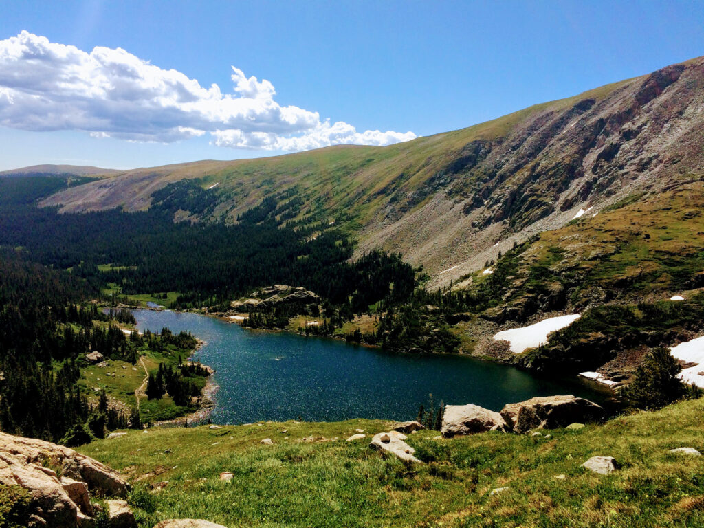
Lake Isabelle
The Lake Isabelle hike is a moderate 4.4 mile hike that offers incredible views without the significant elevation gain required from many other top hikes in the area. This hike is a particularly awesome way to spend a morning or afternoon because of the peaceful scenery around Lake Isabelle and the great views of Niwot Ridge. Moreover, there is a decent chance of seeing wildlife, as moose are known to frequent the area around the lake.
The Lake Isabelle Trail begins at the Long Lake Trailhead, which is accessed via the Brainard Lake Recreation Area. Be prepared to pay a fee when entering the wilderness at the Brainard Lake entrance. Although the Long Lake Trailhead has ample parking, it fills up extremely quickly during peak hiking season because of the area’s close proximity to Boulder and Denver. Therefore, we highly recommend that you get to the trailhead as early as possible to avoid traffic congestion into the wilderness area and not have to park in an overflow lot much further away.
- Round Trip Distance: 4.4 miles
- Elevation Gain: Moderate
- Trail Type: Out and Back
- Trailhead: Long Lake Trailhead
- Coordinates: 40.078005, -105.584557
- Dogs Permitted?: Yes

RECOMMENDED HIKING GEAR & APPAREL
Ten Essentials
All of the referenced hikes above are recommended as day hikes. When hiking in Colorado, you should be prepared for sudden changes in weather, especially at higher elevations. Therefore, you should always carry the appropriate type and amount of gear, clothing, food, water, and other essentials. For certain, make sure that your packing list includes the Ten Essentials.
Trail Runners
We like trail runners for peak-bagging missions because they are lightweight and comfortable. Alternatively, lightweight hiking shoes are a good choice if better ankle support and protection are needed. Select your footwear based on the hike you intend to do in the Indian Peaks Wilderness. If you are planning to be fast and light, trail runners are your best bet. If you intend to be out in the wilderness for an extended period and will be carrying weight beyond a standard day pack, opt for lightweight hiking shoes or boots.
The La Sportiva Bushido II is a great trail running shoe that can double as a durable light hiking shoe. The Bushido II’s weigh about 21oz. and have ample cushioning, suitable foot protection, and impressively good traction. We prefer these shoes for their versatility and think they excel on these Flatirons Vista trails.


Hiking Pants
We love prAna’s hiking pants for their quality and versatility. Indeed, their Zion (for men) and Halle (for women) are great on- and off-trail, especially for travel. Constructed with a durable UPF-50 fabric, a water-repellant finish, and utility pockets, these have become a staple in our wardrobe. Remember that it can be rather chilly at alpine elevations, so consider hiking pants rather than shorts (both for warmth and sun protection).


Hiking Shirt
It can get chilly during alpine outings, particularly when you start early in the morning. Therefore, we typically opt for a long sleeve but lightweight shirt to keep us warm when it’s cold, but keeps us cool when we are working up a sweat later in the day. The no-cotton rule applies to shirts just as it does for pants and other articles of clothing.
Our go-to hiking shirt in the summer is Outdoor Research’s Echo Hoody because of its UPF sun protection qualities and lightweight (4oz.) breathable construction. The shirt has a hood for added neck protection and has thumbholes to protect your hands from sun exposure, if you are not wearing sun gloves. Outdoor Research also makes different varieties of the Echo shirt (e.g., quarter zip, long sleeve without hood, t-shirt, etc.).


Day Pack
Opt for a day pack that is light, versatile, and carries enough volume for your day hiking needs. For instance, on many of our day hiking adventures, we select a pack with about 20L-25L, which is enough for us to carry adequate water, a packed lunch, and other essentials. If you intend to stay out in the wilderness for longer than a day, modify your pack selection for carrying capacity as needed.
For our day hiking needs, we like the Osprey Talon 22L (men’s) or Osprey Tempest 20L (women’s) because they are both high quality, lightweight day packs with ample carrying capacity. These two packs are some of Osprey’s best sellers, and for good reason. They are well-made, versatile packs that will last a long time and can be used as much for travel and city use as for hiking purposes.
The Talon and Tempest come in a variety of sizes: 11L, 22L, 33L, and 44L for the Talon and 9L, 20L, 30L, and 40L for the Tempest. But again, opt for a smaller pack for day hiking.


Trekking Poles
Although trekking poles are optional and a matter of preference, we prefer to use them for added stability. We recommend choosing the lightest weight poles your budget can afford. The Black Diamond Distance Z is our top choice due to its extremely lightweight construction. If you are seeking just one pole, rather than two, consider Gossamer Gear’s LT5, which can be purchased individually.

RECOMMENDED BOOKS
Our favorite guidebook on the area is “Colorado’s Indian Peaks: Classic Hikes and Climbs,” because it is well-written and thoroughly covers the best hikes in Indian Peaks Wilderness. Further, this guidebook was authored by Gerry Roach, who is the leading authority on Colorado’s 14er and 13er hikes. Of course, if you intend to venture into other Colorado wilderness areas beyond Indian Peaks Wilderness, consider a book the covers a wider breadth of area such as “The Complete Guide to Colorado’s Wilderness Areas.” This guidebook is great because it provides excellent information on each wilderness area, including their best hikes and multi-day backcountry outings.
Lastly, we highly recommend bringing along a topographical map of the area where you intend to hike. We suggest the National Geographic Trails Illustrated Map for the Indian Peaks Wilderness. Alternatively, the Sky Terrain Map, which covers Southern Rocky Mountain National Park and Indian Peaks Wilderness, is another excellent option.
- Colorado’s Indian Peaks: Classic Hikes and Climbs
- The Complete Guide to Colorado’s Wilderness Areas
- Indian Peaks, Gold Hill – National Geographic Trails Illustrated Map
- Southern Rocky Mountain National Park & Indian Peaks Wilderness Trail Map
Disclosure: Please note that this post contains affiliate links. We may receive a small commission if you buy a product or service through an affiliate link. This revenue helps us provide readers with helpful content to plan amazing adventures.